Elevating Precision: The Benefits of Drone Photogrammetry
Drone photogrammetry has emerged as a transformative tool in various industries, combining the cutting-edge technology of drones with the precision of photogrammetric techniques. This powerful fusion enables professionals to create detailed and accurate spatial data from aerial imagery, offering numerous benefits across sectors ranging from surveying to construction and environmental management. Here’s a comprehensive look at how drone photogrammetry is revolutionizing data collection and analysis.
High-Resolution Mapping and 3D Modeling
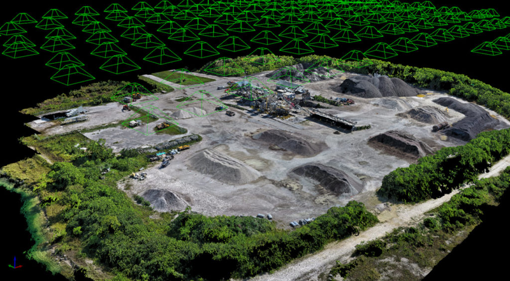
Drone photogrammetry excels in producing high-resolution maps and 3D models with remarkable accuracy. By capturing overlapping photographs from multiple angles, drones create detailed and precise models of terrain, structures, and objects. These models can be used for various applications, including urban planning, landscape design, and architectural visualization. The level of detail provided by drone photogrammetry allows for better decision-making and enhanced project planning.
Cost-Effectiveness and Time Efficiency
Traditionally, generating detailed maps and models required extensive fieldwork and expensive equipment. Drone photogrammetry significantly reduces both costs and time. Drones can cover large areas quickly and efficiently, capturing thousands of images in a single flight. This rapid data collection process translates to faster project completion times and lower overall costs, making it an attractive option for businesses and organizations.
Improved Accuracy and Data Quality
The precision of drone photogrammetry is a major advantage. Drones equipped with high-resolution cameras and advanced GPS systems can achieve centimeter-level accuracy in their measurements. This precision is critical for tasks such as land surveying, construction planning, and infrastructure inspection. The resulting data is highly reliable, reducing errors and enhancing the quality of the final output.
Enhanced Safety and Accessibility
Drone photogrammetry improves safety and accessibility in challenging or hazardous environments. Drones can easily reach areas that are difficult or dangerous for human surveyors, such as steep terrains, high structures, or disaster-stricken zones. By capturing aerial imagery from a safe distance, drones minimize the risks associated with traditional surveying methods and provide valuable data without putting personnel in harm’s way.
Comprehensive Data Analysis and Monitoring
The ability to capture and analyze vast amounts of data is another key benefit of drone photogrammetry. The detailed imagery and measurements obtained can be used to monitor changes over time, assess the impact of environmental factors, and evaluate the progress of construction projects. For instance, in agriculture, farmers can use drone-derived data to monitor crop health and optimize irrigation strategies. In construction, project managers can track progress and identify potential issues early.
Versatility Across Industries
Drone photogrammetry is versatile and applicable across a wide range of industries. In civil engineering, it aids in the design and analysis of infrastructure projects. In archaeology, it helps document and preserve historical sites. In environmental science, it provides critical data for studying ecosystems and assessing the effects of natural disasters. This broad applicability demonstrates the technology’s potential to address diverse challenges and support various fields.
Enhanced Collaboration and Visualization
The visual outputs generated through drone photogrammetry—such as orthophotos, 3D models, and digital elevation models—facilitate better communication and collaboration among stakeholders. These visualizations make complex data more accessible and understandable, enabling teams to make informed decisions and coordinate more effectively. Whether used in client presentations, team meetings, or public consultations, the clear and detailed visual representations enhance the overall planning and development process.
Environmental and Sustainable Practices
Drone photogrammetry contributes to environmentally friendly and sustainable practices. By reducing the need for physical surveys and minimizing the disturbance to natural habitats, drones offer a less intrusive method of data collection. Additionally, the efficiency of drone surveys means fewer resources and lower emissions compared to traditional surveying methods, aligning with sustainable development goals.
Conclusion
Drone photogrammetry represents a significant leap forward in the field of spatial data collection and analysis. Its benefits—ranging from high-resolution mapping and cost savings to enhanced safety and versatility—make it a powerful tool across various industries. As technology continues to advance, the capabilities of drone photogrammetry are likely to expand, offering even greater precision and efficiency. Embracing this technology can unlock new opportunities and drive innovation, ultimately enhancing how we understand and interact with the world around us.

